When many people think of public lands (myself included, until nearly two decades ago) the first things that come to mind are National Parks. Places like Yosemite or Yellowstone or the Grand Canyon. And while for some these are arguably the crown jewels of America’s public land, the entire public land system has a total of 640 million acres, of which our National Parks only make up about 4%. This means there are more places to explore outside of our National Parks than within, each with a unique purpose and beauty that serves a huge variety of users.
Our public lands serve many purposes beyond just outdoor recreation and conservation. They also preserve human historical events and cultural artifacts, support local communities and jobs, provide natural resources, and accommodate interests ranging from pre-history, US history, scientific studies, hunting, the arts, and more. Ultimately, we are all owners of this public land through our tax dollars, and you have the right to explore all the amazing things they offer.
Part one of this three-part article will be to explain the What of public lands, as in what exactly is public land, how it came to be, what are the different types, and who manages it today. Part two will discuss the How, as in how you can access and explore your public lands. Part three will discuss the Why, as in why should anyone care?
The truth is, public lands are part of America’s heritage like baseball and Jazz. And as citizens of the United States (and visitors), you should take every advantage possible in exploring and supporting them for now and future generations.
What is public land?
Because of their enormity in size and function, it can be a challenge to understand what exactly is and isn’t “public land.” To simplify, public lands are, at their most basic, all the acreage of land in America that is not privately owned. In other words, public lands are a communal trust that are owned by all citizens of the United States. A large amount of public land is owned by states and local governments, but for this article we will be talking about federal public lands. Around 40% of land in the US is public and managed by the federal government, 614 million acres of which is open to the public in the form of parks, historic landmarks, forests, wildlife refuges, and much more.
In general, our public lands serve a few key purpose:
- Conservation and preservation (for both natural, cultural and historical purposes)
- Recreation (for you and I to enjoy safely and responsibly)
- Natural resource management and commercial activities (water sheds, air quality, timber production, minerals, oil, natural gas)
Many people dream of visiting ancient ruins in the Middle East, or touring the Alps in Europe. And while I have no doubt they are worthy of being on your bucket lists, it’s refreshing to know there is incredible range of wilderness and historical sites all across the United States that can be just as captivating. Regardless of where you live, there is almost certainly at least one unit of public land nearby (I realize “nearby” means different things for different people). Although it may not be one of the esteemed 60+ National Park units, I can assure you that whatever it is – National Forest, National Wildlife Refuge, National Historical Monument, etc. – it is a significant and beautiful place to visit.
Public lands support the very things we need, and the things that we love. They also put things into perspective. The perspective that we share this world with other species, ecosystems, wildlife, and cultures. A place where you can still hear the chorus of insects and frogs at night, see more stars than darkness in the night sky, witness the might of a grizzly bear, stand in disbelief under giant sequoia trees, or learn of a compelling and dramatic historical event.
The public lands are open to you, the public.
How did the US get all this land?
Before we even had the concept of public lands, we had to acquire these expansive areas, which the US government began to do following its independence in 1776. At one point the federal government owned 1.8 billion acres total, or three quarters of the entire country’s acreage. This was done primarily through massive land acquisitions from other colonial powers.
The map and timeline below describe some of the key land acquisitions which provided the US government with the vast areas of land that would eventually shape the country and public land system:
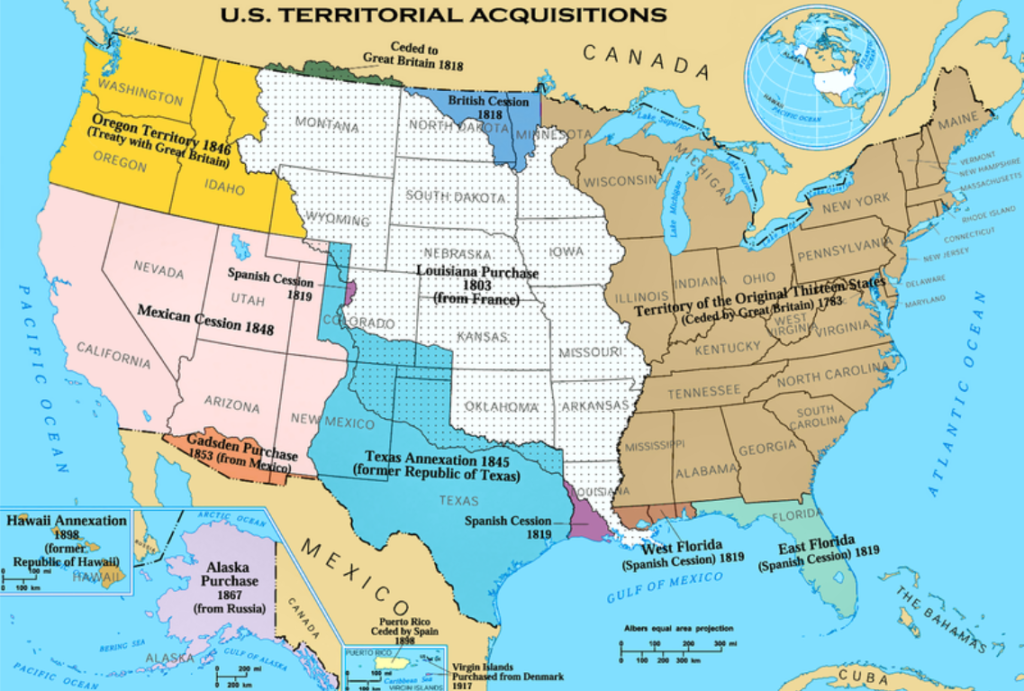
1783 – Northwestern Territories: Not actually a land acquisition but part of the cessions of the Revolutionary War, the US gained the Northwestern Territories from Great Britain under the Treaty of Paris in 1783. This was not the northwest as in the Pacific Northwest (Vancouver, Washington state), but rather the territories to the northwest of the 13 colonies which includes the great lakes regions and surrounding areas. With this acquisition the US gained 340 million acres.
1803 – Louisiana Purchase: This territory stretched from the Gulf of Mexico up to the Canadian border, and from east of the Mississippi to the Rocky Mountains out west. Purchased from France, the Louisiana territory doubled the size of the US, adding 530 million acres at a price of $15 million, roughly 3 cents per acre. The Americans quickly assembled the Lewis and Clark expedition to explore what was considered wild and undeveloped land. However, the Native Americans that inhabited those lands already had an extensive history with Europeans, with several Native American delegations having been to Europe and back nearly 100 years prior to Lewis and Clark.
1819 – Florida Purchase: In the Adams-Onis treaty, the US purchased Florida from the Spanish. This also included a few small areas of modern day Louisiana, Texas, and Colorado. Shortly after in 1821, Mexico gained independence from Spain, which effectively ended Spain’s colonial presence in North America.
1845 – Annexation of the Republic of Texas: In 1836, the Republic of Texas gained independence from Mexico. However, in 1845 that territory was annexed by the US federal government. This area included present day Texas, nearly half of New Mexico, and parts of Kansas, Colorado, and Wyoming. This began America’s conquest of Mexican lands that would shape the majority of the US out west.
1846 – Oregon Territory: In 1818, the US and Great Britain established a boundary at the 49th parallel to distinguish US owned territories and British North America. However, the area to the west of these lands were known as the Oregon Territories and were jointly shared between the two colonial powers. However, tolerance quickly dwindled and in 1846 they came to an agreement in which the US would annex the areas below the 49th parallel, which includes the present day states of Washington, Oregon, Idaho, and parts of Montana and Wyoming.
1848 – Mexican cession: Following the annexation of Texas, the US was engaged in the Mexican-American war between 1846 and 1848, where the US invaded Mexican territory. This resulted in Mexico ceding more than 50% of their land to the US federal government, which included present day states of New Mexico, most of Arizona, California, Nevada, Utah, Colorado, and parts of Wyoming, Oklahoma and Kansas.
1853 – Gadsden Purchase: Following the end of the Mexican-American war, several monetary and land disputes persisted between the two nations. This resulted in the Gadsden Purchase in which the US purchased southern parts of present day Arizona and New Mexico for $10 million. This increased the US land mass by roughly 19 million acres.
1867 – Alaska Purchase: Russia had claim over territory in North America, but had few settlers in those areas. With British influence in the regions, they recognized it would be a challenge to defend this territory and entered into an agreement with the US to sell present day Alaska for $7.2 million. This added 586,412 sq mi to the US.
Expansion into these territories inevitably led to the plight of the Native Americans, which is a tragic outcome of colonialism. We know the indigenous societies of the Americas were not just small tribes dispersed through a vast wilderness, but instead were massive and complex societies spanning across the continent. Of course, native populations were not without violence and wars on their own prior to European arrival. But as the US expanded more than just violence was used against native populations, including federal and state policies that were implemented to systematically displace them. It’s important to acknowledge as part of the history of our public lands.
On a positive note, more efforts have been made recently to involve indigenous tribes when it comes to managing public lands. There are two books about the history of native populations in the Americas that I highly recommend: “1491: New revelations of the Americas before Columbus” by Charles Mann, and “An Indigenous Peoples History of the United States” by Roxanne Dunbar-Ortiz.
When did the modern concept of public lands take hold in the US?
At first, most of the land acquired by the US federal government was a key means of revenue for the young nation with much of it being sold off, or simply given, back to states and private citizens, enabling them to build schools, utilities, and homesteads. This strongly incentivized citizens to leave the east coast and begin populating the new territories the US had acquired or taken. The US also recognized the importance of the resources on these lands to support the nation, and so the management of these resources for the benefit of the public became a key strategy including things like water, timber, minerals, and oil. Although current and historical resource management practices can be highly controversial and politicized, it is a necessary function for a healthy society and natural ecosystems – things like clean water, wildfire mitigation, and energy are all affected by proper, or improper, resource management on public lands.
However, beginning in the late 1800s more dedicated conservation and preservation efforts began. This reflected a shift in the concept of public land as more than just an advantage of resources and territory. Now, the general discourse and attitude among the American public towards conservation and outdoor recreation was dramatically increasing. A defining occasion was the creation of the first national park, Yellowstone, in 1872. Of course, prominent figures in the public arena like Teddy Roosevelt and John Muir (although now highly controversial due to his outspoken bigotry), were huge proponents of conservation and helped the discourse around public lands for both for its inherent beauty and its utility such as hunting, fishing, and recreation. As a result, the US began major efforts to develop and institutionalize the public land system that we see today, with our policies and laws reflecting this effort.
It has taken well over a century for the US to develop and implement the specific models, laws, and practices that are used for public lands and are continually evolving. This also explains why the use of public lands has changed over time as the country’s needs and public desires have changed, and it explains the immense diversity of uses that we get from public lands today. Essentially, these lands are a communal trust to directly benefit the public and future generations. Just what that “benefit” means is open to interpretation and all citizens have a right to weigh in. A major challenge is trying to meet the needs of…well, virtually everyone. From the endemic pupfish species in Death Valley, to indigenous tribes and entire industries. But in pursuit of trying to meet everyone’s needs, the US has built one of the most comprehensive frameworks for managing public lands and conserving wildlife in the world.
One of the overarching principles still guiding public land management is the concept of multiple uses, defined as the “management of the public lands and their various resource values so that they are utilized in the combination that will best meet the present and future needs of the American people (Why should the public care about public lands? By Patagonia).” As a result, some of the most important conservation policies have been implemented by the US, with many other countries modeling their efforts after ours. This includes landmark policies and principles such as the Endangered Species Act, the Clean Water Act, the Clean Air Act, the North American Model for Wildlife Conservation, the Antiquities Act, the Land and Water Conservation Fund, and countless others.
Of course, these policies and laws can be, and are, highly criticized. For example, the Timber Wars during the 1980s brought many things into the spotlight, such as the dwindling old growth forests of the Pacific Northwest, small threatened species like the spotted owl, as well as the entire timber industry and the communities and jobs they supported. This initially resulted in several new policies that neither the environmental groups nor the timber industry was happy with (check out this excellent 7 part podcast on the Timber Wars by Aaron Scott). However, these policies are still being improved upon to meet the evolving needs of today’s world and common grounds have been found. Progress has been made.
Today, the public lands still make up one third of the country and support a wildly diverse group of people such as sportsmen, anglers, outdoor recreationalists, indigenous and tribal communities, natural resource managers, livestock grazers, agriculturalists, archaeologists, historians, grassroots organizations and coalitions, environmental protection groups, scientific and educational institutions, recreational companies and countless others.
With all the challenges facing humans and wildlife today, it’s reassuring to know a wide range of people take interest in conservation and wilderness protection.
What are the different types of public land?
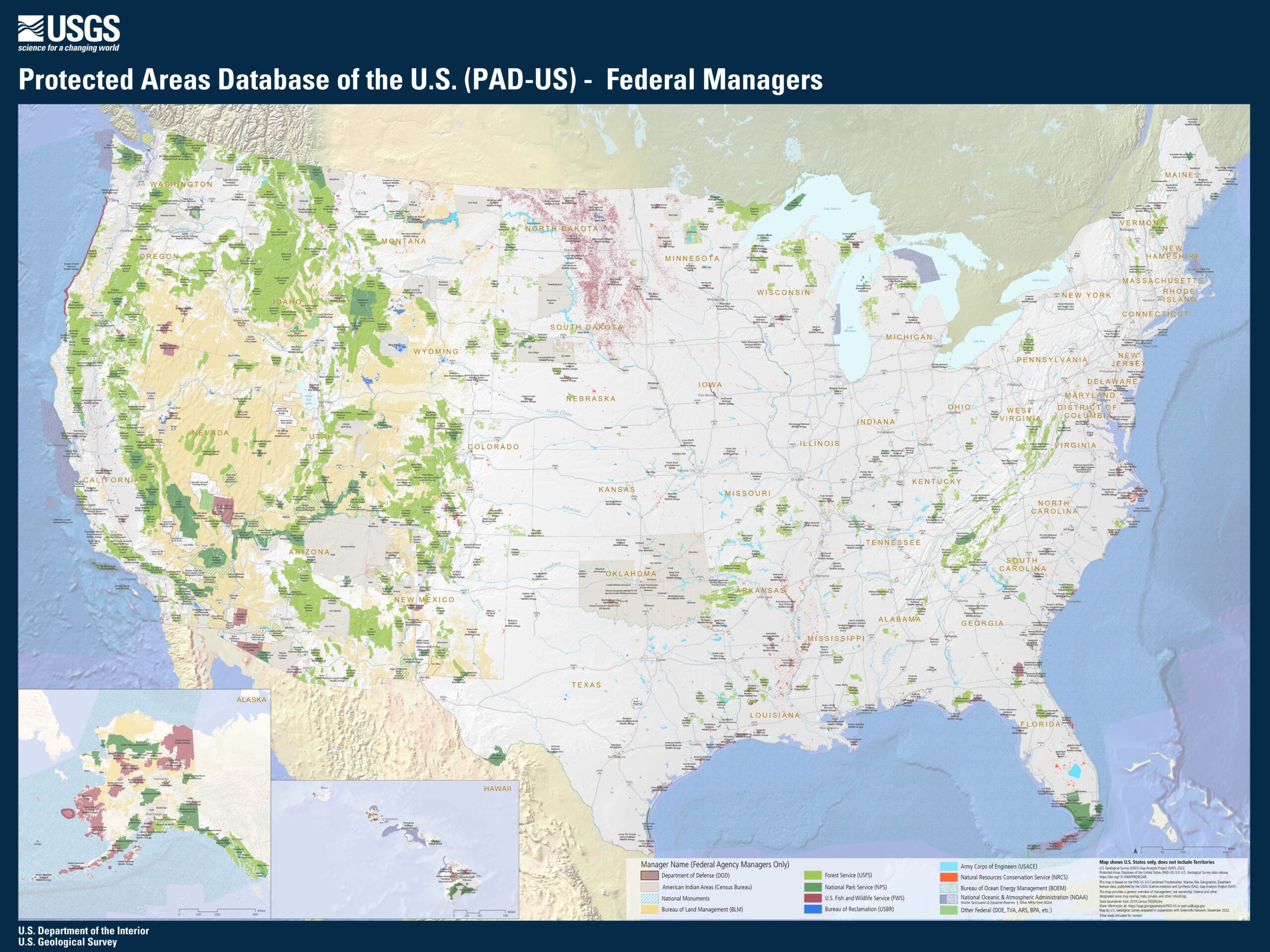
The majority of federal public lands are managed by four agencies – the National Forest Service, the US Fish and Wildlife Service, the National Park Service, and the Bureau of Land Management. Public land can also be managed by the Bureau of Indian Affairs, Bureau of Reclamation, National Oceanic and Atmospheric Administration, the Army Corps of Engineers, and other government agencies.
However, the four main agencies manage dozens of different types of public land, which have their own unique designations and sub-designations that determine how the land will be used. Each specific area is typically called a “unit.”
The Bureau of Land Management
The Bureau of Land Management (under the Department of the Interior) oversees the largest portion of public land with about 250 million surface acres, which is close to one out of every ten acres in the entire US. The BLM has a dual mandate in their mission, which is to manage the land for multiple uses (timber, natural resources, etc.) as well as conserving natural, historical and cultural areas. Because of their enormous stake in public lands, their is a lot of concern from the public on how much of their land is open to leasing to extraction companies as opposed to conservation, recreation, hunting grounds. However, the conservation areas that the BLM does manage are excellent and include places like Wilderness Areas, National Monuments, and National Conservation Lands. You’ll also find National Scenic Trails like parts of the Pacific Crest Trail, or National Historic Trails such as the Lewis and Clark Trail. Likewise, the BLM lands typically have much fewer restrictions than you’d find in places like National Parks. This attracts a larger variety of recreationalists from traditional backpackers and hikers, to off-roading enthusiasts, hunters and recreational shooters.
Areas managed by the BLM (250 million acres):
- Wilderness Areas (806 units+ between all agencies)
- National Monuments (130+ units)
- National Recreation Sites
- The National Conservation Lands (905+ units)
- National Conservation Area
- National Historic Trails
- National Scenic Trails
- Wild and Scenic Rivers
- Natural Areas
- Special Recreation Management Areas
- Wilderness Study Areas
See our guide for a 1 night desert backpacking trip in the Coyote Mountains Wilderness in California.
The National Forest Service
The National Forest Service manages almost 200 million acres, and is primarily made up of National Forests (150+), National Grasslands (20+), and also Wilderness Areas. Created in 1905 and sitting under the Department of Agriculture, their primary goal is “to maintain and improve the health, diversity, and productivity of the nation’s forests and grasslands to meet the needs of current and future generations.” Today, the NFS manages the lands for a multitude of uses, which includes outdoor recreation, fish and wildlife management, natural resource management like timber, minerals, energy, watersheds, livestock ranges, and also wilderness preservation and ecosystem restoration. National Forests are one of my personal favorite areas to explore because you can experience hikes just as majestic as national parks, but without the crowds. Don’t hesitate to speak with forest rangers for their recommendations.
Areas managed by the National Forest Service (193 million acres):
- Wilderness Areas (806+ units between all agencies)
- National Forests (150+ units)
- National Grasslands (20+ units)
See our guide for camping at Onion Valley Campground in the Inyo National Forest in California.
The US Fish and Wildlife Service
The US Fish and Wildlife Service (under the Department of the Interior) manages 95 million acres on land, and over 755 million acres on water across all 50 US States, which is mostly composed of units called National Wildlife Refuges. The agency’s main goal is to protect and restore wildlife species and ecosystems. They also address important challenges such as wildlife trafficking, invasive species management, hunting/fishing and wildlife management, pollination, and climate change mitigation. According to the US Fish and Wildlife Service, the wildlife refuge units are “established to serve a statutory purpose that targets the conservation of native species dependent on its lands and water. All activities on those acres are reviewed for compatibility with this statutory purpose.” Very few of them have camping areas, but this aids in their conservation efforts to protect delicate ecosystems, migratory patterns and wildlife protection.
Areas managed by the US Fish & Wildlife Service (89 million acres):
- Wilderness Areas (806+ units between all agencies)
- The National Wildlife Refuge System (590+ units)
- Wildlife Refuge
- Wetland Management District
- Migratory Bird Refuge
- Wildlife Management Area
- Wildlife Conservation Area
- Waterfowl Production Area
The National Park Service
Finally, there is the National Park Service (under the Department of the Interior), which manages 85 million acres, including some of the most scenic parts of the country like Olympic National Park and Zion National Park. However, what is not known to most is that they manage dozens of other units – nearly 425 in all 50 states – including National Battlegrounds like Gettysburg, National Historic Sites like the tragic Sand Creek Massacre, or Mesa Verde which preserves priceless cultural artifacts of the Ancestral Pueblo people of Colorado. The very mission of the National Park service “preserves unimpaired the natural and cultural resources and values of the National Park System for the enjoyment, education, and inspiration of this and future generations.” So you don’t have to worry about securing Glacier reservations to see some amazing National Park units.
Areas managed by the National Park Service (84 million acres):
- Wilderness Areas (806+ between all agencies)
- National Monuments (84)
- National Parks (63)
- National Battlefields (11)
- National Battlefield Parks (4)
- National Battlefield Sites (1)
- National Military Parks (9)
- National Historic Parks (9)
- National Historic Sites (74)
- International Historic Sites (1)
- National Lakeshores (3)
- National Memorials (31)
- National Monuments (84)
- National Parkways (4)
- National Preserves (19)
- National Reserves (2)
- National Recreation Areas (18)
- National Rivers (4)
- National Wild and Scenic Rivers and Riverways (10)
- National Scenic Trails (3)
- National Seashores (10)
- Other Designations (11)
See our 3 night camping itinerary in Death Valley National Park.
How do I explore the public land system?
You have a lot of land to explore. But what are the rules? How do I navigate these areas? Do they all offer the same activities and facilities?
To see how you can explore and enjoy our public lands today, read part 2, How To Explore the Public Lands in America. To learn more about how much of an impact public lands have on our well being, the economy, and preserving natural and cultural sites, read part 3 of our public land series, Why America’s Public Lands Are Important for Everyone.
Enjoy the journey – J. Wasko

About the author
Jeremy Wasko has been exploring our public lands for over two decades, with thousands of miles and hundreds of camping trips completed. Through his adventures, he discovered that our public lands are more than just places to camp and recreate. They are cultural and historical sites, the very sources of our clean water and air, and places that can create lifetime memories.
He created Magna Terra to share his knowledge on how to explore and enjoy our public lands, and also how to protect and conserve them for future generations.
Learn more about Jeremy and the founding of Magna Terra here.
* Please note Magna Terra does not have any affiliation with any of the agencies, products, or links referenced in this post, and we are providing the information purely from personal recommendation and experience.
Sources
- https://www.rei.com/blog/hike/your-guide-to-understanding-public-lands
- https://www.npca.org/resources/3202-what-is-a-national-monument?_gl=1nta3r5_gaMTgzMjI5MTQ5Ny4xNjk5MjIwNzE5_ga_1SYPSJZYJ5*MTY5OTIyMjc3MS4yLjEuMTY5OTIyMzM3NC4wLjAuMA..#sm.0000w1n5fu19xew7103fiyhz66ah2
- https://www.doi.gov/blog/americas-public-lands-explained
- https://www.nps.gov/goga/planyourvisit/designations.htm
- https://www.blm.gov/about
- https://www.wilderness.org/sites/default/files/media/file/Module%201%20-%20Reading.pdf
- https://www.publiclands.com/blog/a/public-lands-in-the-united-states
- https://www.nps.gov/aboutus/national-park-system.htm
- https://www.fs.usda.gov/managing-land/wilderness
- https://wilderness.net/learn-about-wilderness/regulations.php
- https://www.npca.org/resources/3202-what-is-a-national-monument?_gl=152lt7h_gaMTgzMjI5MTQ5Ny4xNjk5MjIwNzE5_ga_1SYPSJZYJ5*MTY5OTIyMjc3MS4yLjEuMTY5OTIyMzM3NC4wLjAuMA..#sm.0000w1n5fu19xew7103fiyhz66ah2
- https://www.npca.org/
- www.conservationnw.org
- https://www.fieldandstream.com/keep-public-lands-in-public-hands/?src=SOC&dom=fb&_gl=1g1wdur_gaMTgzMjI5MTQ5Ny4xNjk5MjIwNzE5_ga_1SYPSJZYJ5*MTY5OTIyMDcxOS4xLjAuMTY5OTIyMDcxOS4wLjAuMA..
- https://www.fws.gov/story/camping-treat-these-national-wildlife-refuges
- https://en.wikipedia.org/wiki/Northwest_Territory#:~:text=Britain%20officially%20ceded%20the%20area,of%20the%20War%20of%201812
- https://www.fs.usda.gov/managing-land/national-forests-grasslands/water-facts#:~:text=Forest%20Service%20lands%20are%20located,3%2C400%20communities%20in%2033%20States.
- https://publicland.org/wp-content/uploads/2016/08/150359_Public_Lands_Document_web.pdf
- https://www.wilderness.org/sites/default/files/media/file/Module%202%20-%20Reading.pdf
- https://www.history.com/topics/19th-century/louisiana-purchase
- https://www.treehugger.com/countries-largest-amount-protected-land-4858224
- https://en.wikipedia.org/wiki/Adams%E2%80%93On%C3%ADs_Treaty
- https://www.historytoday.com/archive/gadsden-purchase
- https://en.wikipedia.org/wiki/Texas_annexation
- https://sgp.fas.org/crs/misc/R42346.pdf
- https://www.publiclands.com/blog/a/public-lands-in-the-united-states
- https://www.smithsonianmag.com/history/the-indigenous-americans-who-visited-europe-180981496/
- https://www.historytoday.com/archive/gadsden-purchase
- https://www.rei.com/blog/hike/your-guide-to-understanding-public-lands