Each public land area and designation in the United States has a different set of rules and requirements, some more so than others, dictating how that region can be accessed and which activities are permitted on the land. All too often individuals and groups show up at a National Park, trailhead, or campsite, only to realize they need vehicle reservations, a special camping permit, a 4WD vehicle, cash for day-use fees, etc. Or that the area is for foot traffic only or OHV’s (off highway vehicles) are not allowed. This can ruin your trip and experience and this is why planning ahead is so important. Hopefully this post makes planning a bit easier.
Below is a breakdown of the different types of public lands, how you can explore them, and the must know details like fees/permits, activities allowed, and navigational tips for each.
How to explore National Parks
Managed by the National Park Service
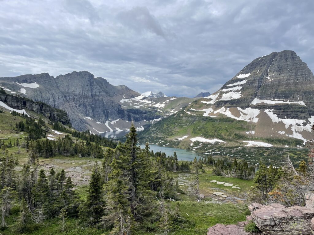
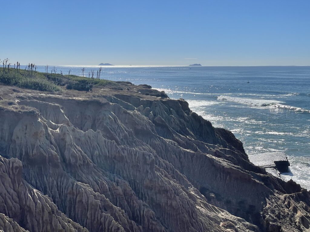
Glacier National Park
Why National Parks are great
The National Park system has something for everyone. While most people think of National Parks as comprising only natural parks, with forests and mountains, natural parks only account for 63 of the 425+ units in the National Park system. The National Park system manages dozens of historical sites, such as Gettysburg Battleground (Gettysburg National Military Park), the 1800s Dry Tortugas Fort in the Florida Keys (Dry Tortugas National Park), and the site of Booker T Washington’s birthplace (Booker T Washington National Monument). These are places to learn and discover the history and culture of your surrounding areas, and without them we risk losing some of the most important natural, cultural, and historical sites in the US.
With units in all 50 states, there is likely a National Park within driving distance of your home. This means you don’t have to plan an expensive and lengthy trip to California or Montana just to enjoy a National Park. Get out there and see what the National Park System has to offer locally. For some motivation, there was one man who visited every National Park unit in one year and documented his experience. You can listen to his story on the Adventure Sports Podcast – Visiting every National Park in a year.
Fees/reservations/passes & permits for National Parks
Most National Parks charge an entrance fee. Visit this link for a list of fees – Entrance Fees for National Parks.
During “National Park Week” between April 22 – April 30, all National Parks are free.
Depending on the National Park and time of year, you may be required to have a vehicle reservation or permit to access the park or specific areas of the park. Don’t make the mistake many people make like planning a vacay then finding out you can’t even access the park. Always check the individual parks website for up to date information – Find a National Park.
If a National Park does require reservations for your vehicle to enter, those are typically sold on Recreation.gov, or by contacting the local field office of the National Park.
As with all federal lands you can purchase annual passes like the America the Beautiful pass, which provide access to all federally managed lands such as National Park entrance fees or day use areas (this typically does not include fees for campsites, nor fees for special road access like in the case of Glacier National Park).
Navigating the National Parks
Physical/topographical maps – Paper maps (or nowadays usually vinyl) are a must have when adventuring. Never rely solely on your phone, apps, or electronics to navigate. A paper topographical map will display the elevation of a given area, and should display local trails, roads and boundaries. Likewise, be sure to keep a current version of the map as the magnetic poles are continually moving and it will affect your orientation and bearings with a compass. Find topographical National Park maps here – National Park Service Maps
Apps – The NPS has a great phone app which helps you navigate everything and anything related to the National Park system, including all 425+ units – National Park Service app for iOS. My preferred app for exploration is Gaia GPS, which has multiple map layers and tracking options. Download here – Gaia GPS
Visit the National Parks website here for updates, directions, etc. – The National Park Service
Camping in National Parks
Campgrounds in National Parks – National Parks have some of the best campgrounds. For a list of camping areas, visit this page – Camping opportunities in National Parks. Campgrounds are great to have some comforts but also be in nature, or as a staging area for great day hikes. Reservations for campgrounds at National Parks can usually be made calling or visiting the local field office, or reserving on Recreation.gov.
Dispersed camping and car camping in National Parks – This is almost never an option in National Parks and you will have to either reserve a campsite, or acquire a backpacking permit.
Backpacking and backcountry camping in National Parks – Getting in to the backcountry of National Parks is sure to provide some of the more beautiful and humbling camping experiences you may have. Permits are usually required for backpacking in National Parks, some of which are done on a lottery system and require significant planning (like Mt. Whitney). Check the National Parks’ website for details on which backcountry permits are available. You can typically reserve them by calling, or at the Visitors Center, or also on Recreation.gov.
In general, it’s always recommended to visit an individual National Parks website for detailed information – Find a National Park.
For clarity, we break camping down into the following types:
- Campgrounds – These have designated campsites, and may include facilities and services such as parking, bathrooms, fire rings, a campground host, and more. Please note that campgrounds can vary significantly, with some more primitive than others.
- Dispersed camping and car camping – Dispersed camping (often done as car camping is any camping that is outside of a designated campground and does not have any facilities or services. This is typically done by driving down a forest service road and pulling over to a suitable camp area to set up your tent and campsite.
- Backpacking/backcountry camping – when you carry all of your supplies, food, etc. in a backpack and hike into a remote area by foot and camp.
Check out a 3 night camping itinerary in Death Valley National Park by Magna Terra.
Recreation in National Parks
Hiking, fishing, backpacking, educational and historical tours, climbing, kayaking, canoeing, mountain biking, backcountry skiing, cross country skiing, snow shoeing, mountaineering…I could keep going, but I will leave the exploration up to you.
The National Park system also has different programs and activities that might be overlooked from traditional outdoor activities. These includes kids programs, educational tours, fossil digging, astronomy programs, ranger lead activities, and more. Explore the NPS site here for more details – Learn and explore with the NPS
Hunting is mostly forbidden in National Parks, although there are a few select units that allow for it – Hunting in the NPS
Important guidelines for National Parks
Please leave the place better than you found it and practice the guidelines below.
- Leave No Trace Principles
- The National Park Service has an excellent series of articles called “I didn’t know that!” which provides great tips and info on how to recreate responsibly – I didn’t know that! by the NPS
Additional resources
The National Park Service website is a great resource for up to date information on the current status and access to parks – National Park Service.
How to explore National Forests & Grasslands
Managed by the National Forest Service
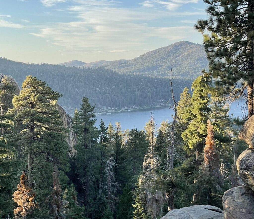
San Bernardino National Forest
Why National Forests & Grasslands are great
Discovering National Forests & Grasslands was my biggest “oh wow” moment several decades ago. I asked myself, “where can I get completely lost in the wild on my own? Are there any places like this besides National Parks?” Short answer…yes. A lot of places. More than you could imagine.
Through some diligent research, I realized there are these massive swaths of land, forests, and mountains which you can explore at your discretion on trails or by cruising on forest service roads – and these are primarily located within National Forest areas. Forest service roads are what they sound like – a road that allows the NFS to service the forest whether that’s for trail maintenance, timber production, or wildfire mitigation. But with a proper AWD/4WD vehicle, you can access these roads and get deep into the forest or mountains where you’ll find great dispersed camping spots or hard to reach trailheads.
There are currently over 193 million acres of national forests and grasslands, which contain over 4,500 miles of trails. If you want to get lost in epic mountains, drive down forest service roads, go car camping, backpacking, hunting, kayaking – almost anything you can think of – this is a great place to start.
Fees/reservations/passes & permits
Free (for the most part). Most National Forests and Grasslands do not charge a fee for access or recreation. This is one of the many amazing things about the National Forest System. However, this depends on the location and activity you’re participating in.
Check here for detailed information on whether you need a permit or day pass of some kind – NSF Passes and Permits. Or it’s always recommended to contact the local ranger station prior to visiting.
As with all federal lands, you can purchase annual passes like the America the Beautiful pass, which provide access to all federally managed lands and generally cover entrance fees or day use areas (note that this does not include fees for campsites).
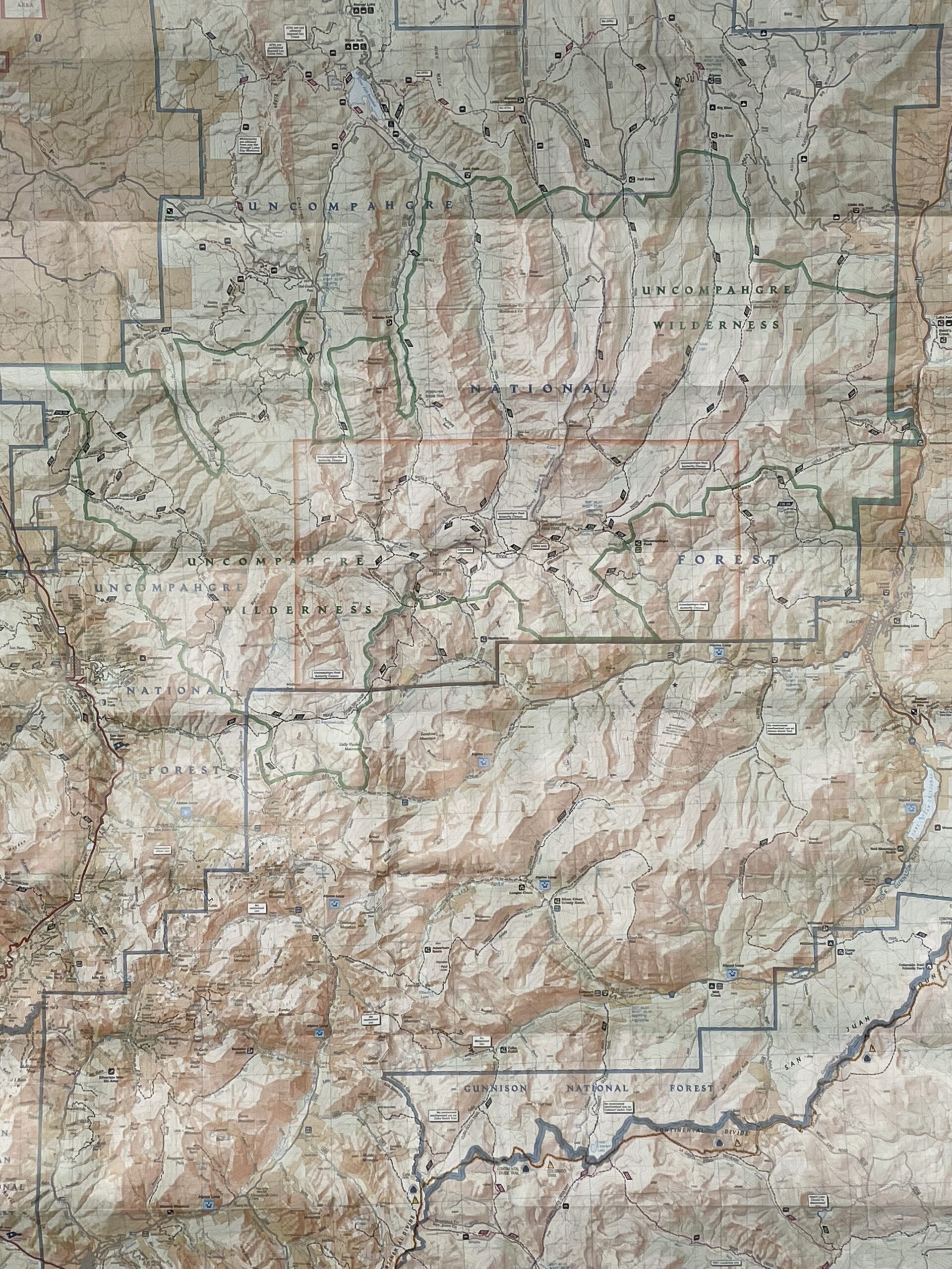
Navigating National Forests & Grasslands
Depending on your goal, I highly recommend getting one of several maps or navigation tools. I consider these the most important:
Physical/topographical maps – Paper maps (or nowadays usually vinyl) are a must have when adventuring. Never rely solely on your phone, apps, or electronics to navigate. A paper topographical map will display the elevation of a given area, and should display local trails, roads and boundaries. Likewise, be sure to keep a current version of the map as the magnetic poles are continually moving and it will affect your orientation and bearings with a compass. My favorite topographical maps are either from the US Geological Survey https://store.usgs.gov/fsmaps, or the National Geographic Maps https://www.natgeomaps.com/.
Motor Vehicle Use Maps (MVUM) – These are some of the most critical, and least known maps to have at your disposal. If you are going to explore the National Forests and Grasslands in your car, you should download and/or print these maps. Motor Vehicle Use Maps show you public and private land boundaries, and the forest service roads that run through them. A forest service road is a road specifically made for servicing and/or accessing the national forests and grasslands – this can be anything from addressing wildfires, for natural resource management like timber collection, and recreational opportunities to access trailheads, campsites, and points of interest. It’s your vehicular gateway to these amazing areas.
Interactive digital maps – The National Forest Service has its own interactive map which gives a great overview of trails, campgrounds, boundaries, and more. If you’re not sure where to begin, or want a comprehensive review of the National Forests & Grasslands, this is a great place to start – National Forest Interactive Visitor Map
Apps – My preferred app for exploration is Gaia GPS, which has multiple map layers and tracking options. Download here – Gaia GPS
Camping in National Forests & Grasslands
There are seemingly endless camping opportunities in the National Forests and Grasslands, including campgrounds with facilities, dispersed camping and backpacking.
Campgrounds in National Forests & Grasslands – National Forests and Grasslands offer many different campgrounds, some more primitive than others. These are great to have some comforts but also be in nature, or to serve as a staging area for great day hikes. Some campsites are available on a first-come first-served basis, and others require reservations. Most all campgrounds have a fee which can be paid in advance or upon arrival (recommended to always bring cash). Reservations for camping can usually be made calling or visiting the local field office, or reserving on Recreation.gov.
Dispersed camping (car camping) in National Forests and Grasslands – Dispersed camping is any camping that is outside of a designated campground and does not have any facilities or services. National Forests and Grasslands are great for dispersed camping, especially when accessing them via forest service roads. To find a forest service road you can use MVUM maps (see above). When done properly and safely, this is a great way to camp outside of designated campgrounds or create a basecamp for hard to access trailheads and wilderness areas.
Backpacking and backcountry camping in National Forest and Grasslands – Backpacking/backcountry camping is when you carry all of your supplies, food, etc. in a backpack and hike into a remote area by foot and camp. With over 4,500 miles of trails in the National Forests and Grasslands, you have a lifetime of opportunities to backpack and see places that are not accessible otherwise. Backpacking is a serious endeavor, even for short trips, but it can be very rewarding.
For clarity, we break down camping into the following types:
- Campgrounds – These have designated campsites, and may include facilities and services such as parking, bathrooms, fire rings, a campground host, and more. Please note that campgrounds can vary significantly, with some more primitive than others.
- Dispersed camping and car camping – Dispersed camping (often done as car camping is any camping that is outside of a designated campground and does not have any facilities or services. This is typically done by driving down a forest service road and pulling over to a suitable camp area to set up your tent and campsite.
- Backpacking/backcountry camping – when you carry all of your supplies, food, etc. in a backpack and hike into a remote area by foot and camp.
Check out a guide to camping at Onion Valley Campground in the Inyo National Forest in California.
Other recreation in National Forests & Grasslands
Hiking, climbing, fishing, camping, hunting, kayaking, canoeing, mountain biking, backcountry skiing, cross country skiing, snow shoeing, mountaineering, off-roading…I could keep going, but I will leave the exploration up to you.
Visit the USFS website here for details on recreation opportunities – Recreating on National Forests and Grasslands
Important guidelines for National Forests & Grasslands
Please leave the place better than you found it and practice the guidelines below.
Additional resources
Official site of the US National Forest Service – https://www.fs.usda.gov/.
How to explore Wilderness Areas
Managed by the National Forest Service, National Park Service, US Fish and Wildlife Service, and The Bureau of Land Management
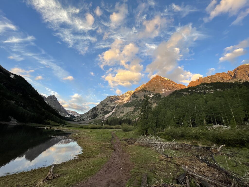
Maroon Bells Wilderness
Why Wilderness Areas are great
A “Wilderness Area” is one of the most protected designations that can be awarded to a public land. This means they have some stricter regulations:
- Only accessibly by foot
- No motorized or mechanical vehicles of any kind, including cars, mountain bikes, or motorboats
- No motorized equipment of any kind, including drones
- No dogs or pets (in most cases)
But these rules are what make Wilderness Areas all the more appealing. They are the most “untouched” and pristine natural settings in the country. With over 111 million acres and 806+ units, there’s nothing quite as immersive as hiking or camping in a Wilderness Area. But it is doubly challenging since you must be more resourceful and cautious as there are no facilities, amenities, or roads to assist you.
Established by the Wilderness Act of 1964, these areas are co-managed by the four main agencies (NFS, NPS, BLM, USFWS). This quote taken from the Wilderness Act sums up its purpose well:
“In order to assure that an increasing population, accompanied by expanding settlement and growing mechanization, does not occupy and modify all areas within the United States and its possessions, leaving no lands designated for preservation and protection in their natural condition, it is hereby declared to be the policy of the Congress to secure for the American people of present and future generations the benefits of an enduring resource of wilderness.”
These are some of the most pristine forests, rivers, mountains, and deserts this country has to offer, and I’d highly recommend visiting them.
Fees/reservations/passes & permits
Each Wilderness Area has different regulations and restrictions. To find out whether you need a day use/overnight use permit, or any other kind of permit, I recommend visiting the following site: Wilderness Connect – find a wilderness . Here you can type in the name of a State or Wilderness Area, or explore their interactive map. Once you find a Wilderness Area, check the “Rules and Regulations” menu. This will tell you what’s required and how to obtain any necessary permits.
Even if permits aren’t required, most Wilderness Areas will have a free permit at each trailhead to fill out, which you should absolutely do. It’s critical that rangers can monitor how many people accessed the area, and when, so they can send SAR teams (Search and Rescue) if required, or make adjustments to management practices based on the volume of visitors. Don’t be that person who goes exploring in the wilderness, gets injured, and didn’t leave a note…
As with all federal lands, you can purchase annual passes like the America the Beautiful pass, which provide access to all federally managed lands and generally cover entrance fees or day use areas (note that this does not include fees for campsites).
Navigating Wilderness Areas
Physical/topographical maps – Paper maps (or nowadays usually vinyl) are a must have when adventuring. Never rely solely on your phone, apps, or electronics to navigate. A paper topographical map will display the elevation of a given area, and should display local trails, roads and boundaries. Likewise, be sure to keep a current version of the map as the magnetic poles are continually moving and it will affect your orientation and bearings with a compass. My favorite topographical maps are either from the US Geological Survey – https://store.usgs.gov/fsmaps, or the National Geographic Maps – https://www.natgeomaps.com/.
Interactive Digital Maps – An excellent way to discover and understand a Wilderness Area is through this great interactive map – Interactive Map for Wilderness Areas
Apps – My preferred app for exploration is Gaia GPS, which has multiple map layers and tracking options. Download here – Gaia GPS
There are no MVUM’s (Motor Vehicle Use Maps) because motor vehicles are not allowed in Wilderness Areas. This includes bikes.
Camping in Wilderness Areas
Campgrounds in Wilderness Areas – Technically campgrounds are available in Wilderness Areas, but you must backpack to them and they will almost certainly be primitive with just a flat area for a tent and possibly a fire ring, maybe an outhouse if you’re lucky. These sites can be highly coveted in a Wilderness Area, so plan well in advance and check with your local ranger station on how to obtain a permit, or make reservations on Recreation.gov.
Dispersed camping and car camping – This is not an option in Wilderness Areas because there are no roads. You could technically car camp right outside the perimeter of a Wilderness Area and stage your trips from there, but really the only option is to backpack.
Backpacking and backcountry camping – This is the only option when it comes to Wilderness Areas, which is why you’re bound to see some the best nature our country has to offer. Backpacking is a serious endeavor, even for short trips, but it can be very rewarding. Camping in Wilderness Areas has some important guidelines, which are outlined by a great organization called Wilderness Connect here – Camping in the wilderness. They also have a great page to find a wilderness near you – Wilderness Connect – find a wilderness .
For clarity, we break down camping into the following types:
- Campgrounds – These have designated campsites, and may include facilities and services such as parking, bathrooms, fire rings, a campground host, and more. Please note that campgrounds can vary significantly, with some more primitive than others.
- Dispersed camping and car camping – Dispersed camping (often done as car camping is any camping that is outside of a designated campground and does not have any facilities or services. This is typically done by driving down a forest service road and pulling over to a suitable camp area to set up your tent and campsite.
- Backpacking/backcountry camping – when you carry all of your supplies, food, etc. in a backpack and hike into a remote area by foot and camp.
Check out a guide for a 1 night desert backpacking trip in the Coyote Mountains Wilderness in California.
Recreation in Wilderness Areas
Hunting, fishing, rock climbing, kayaking, canoeing, backcountry skiing, cross country skiing, snow shoeing, mountaineering…there are plenty of other things to do, but keep in mind that wilderness areas are restricted to more primitive activities. This means no mountain biking, mechanical or motorized vehicles or boats, or electronics of any kind including drones.
See a more extensive list of regulations around activities here – Wilderness Regulations
Important guidelines for Wilderness Areas
Please leave the place better than you found it and practice the guidelines below.
- Leave No Trace Principles
- Find your local Wilderness Area regulations by contacting your local ranger station or visiting this site – Wilderness Connect.
Magna Terra Wilderness Guides
Magna Terra provides detailed trip guides for certain Wilderness Areas. Select an area below to find more details on hiking and camping opportunities.
Additional resources
Wilderness Connect is a great organization from the University of Montana which provides details all things Wilderness – Wilderness Connect.
How to explore National Monuments
Managed by the US Fish and Wildlife Service, the National Park Service, the National Forest Service, the Bureau of Land Management, the National Oceanic and Atmospheric Organization
Cabrillo National Monument
Why National Monuments are great
National Monuments should always be in consideration for an adventure. It’s easy to feel drawn to the popularity of the National Parks, but the truth is National Monuments are no less exceptional for awe inspiring landscapes or historical and cultural sites. They may even be more accessible to you than National Parks, geographically speaking. These can range from things like the Statue of Liberty in New York to the Devils Tower in Wyoming. There are currently 161+ National Monuments in 32 states.
A key distinction to National Monuments is they do not always require an act of Congress to pass them (unlike other public lands). They can also be designated by an acting president through the Antiquities Act. This is not terribly exciting on the surface, but can have a huge impact on the protection of important natural, cultural, and historical areas.
Fees/reservations/passes & permits
All National Monuments are pretty unique and hard to pin down to one particular type of setting or environment. Likewise, they can be managed by any of the 4 primary agencies, so the best thing to do is research the specific monument you wish to visit, and verify any fees or permits required. Check out this comprehensive list to find the National Monument you wish to explore – List of National Monuments and the managing agency.
As with all federal lands, you can purchase annual passes like the America the Beautiful pass, which provides access to all federally managed lands and generally cover entrance fees or day use areas (note that this does not include fees for campsites).
Navigating National Monuments
Physical/topographical maps – Paper maps (or nowadays usually vinyl) are a must have when adventuring. Never rely solely on your phone, apps, or electronics to navigate. A paper topographical map will display the elevation of a given area, and should display local trails, roads and boundaries. Likewise, be sure to keep a current version of the map as the magnetic poles are continually moving and it will affect your orientation on the map and bearings with a compass. My favorite maps are from the US Geological Survey – https://store.usgs.gov/fsmaps, or the National Geographic Maps – https://www.natgeomaps.com/.
Interactive digital maps – Because they can be managed by different agencies, there are different digital maps available. I’d recommend visiting the different agency websites to explore what they have, which includes:
- NPS maps – https://www.nps.gov/planyourvisit/maps.htm
- NSFS maps – https://www.fs.usda.gov/visit/maps
- BLM maps – https://www.blm.gov/maps
- USFWS maps – https://www.fws.gov/library/categories/maps
Apps – My preferred app for exploration is Gaia GPS, which has multiple map layers and tracking options. Download here – Gaia GPS.
Camping in National Monuments
Yes, you can camp in certain National Monuments but not all of them (like the Statue of Liberty, for example…). Because they are so varied it’s recommended to research the individual monument you wish to visit and see what recreational and camping activities are available.
Thankfully, the National Park Service has done an excellent job of creating a dataset that reviews all National Monuments and who is the respective managing agency – List of National Monuments and the managing agency. Reservations for camping can usually be made calling or visiting the local field office, or reserving on Recreation.gov.
For clarity, we break down camping into the following types:
- Campgrounds – These have designated campsites, and may include facilities and services such as parking, bathrooms, fire rings, a campground host, and more. Please note that campgrounds can vary significantly, with some more primitive than others.
- Dispersed camping and car camping – Dispersed camping (often done as car camping is any camping that is outside of a designated campground and does not have any facilities or services. This is typically done by driving down a forest service road and pulling over to a suitable camp area to set up your tent and campsite.
- Backpacking/backcountry camping – when you carry all of your supplies, food, etc. in a backpack and hike into a remote area by foot and camp.
Other recreation in National Monuments
You can enjoy many things in National Monuments like hiking and climbing to educational tours and cultural experiences. However, as mentioned above it’s recommended to research the individual monument you wish to visit and see what recreational activities are available.
Thankfully, the National Park Service has done an excellent job of creating a dataset that reviews all National Monuments, and who is the respective managing agency – List of National Monuments and the managing agency.
Important guidelines for National Monuments
Please leave the place better than you found it and practice the guidelines below.
Additional resources
- Comprehensive list of National Monuments – List of National Monuments and the managing agency
- National Monuments managed by the National Park Service – NPS National Monuments
- National Monuments managed by the National Forest Service – NFS National Monuments
- National Monuments managed by the US Fish and Wildlife Service – USFWS National Monuments
- National Monuments managed by the Bureau of Land Management – BLM National Monuments
How to explore National Wildlife Refuges
Managed by the US Fish and Wildlife Service
San Diego National Wildlife Refuge – photo by John Martin/USFWS
Why National Wildlife Refuges are great
The National Wildlife Refuge system is great because it places the protection and health of wild animals and ecosystems first, and recreation for humans comes second. Yes, there are amazing recreational opportunities on them, but according to the US Fish and Wildlife Service they “serve a statutory purpose that targets the conservation of native species dependent on its lands and water.” Some wild areas simply need a break from human activity to thrive, and that’s exactly what Wildlife Refuges help achieve. They also address key initiatives such as wildlife trafficking, invasive species management, wildlife hunting/fishing management, pollination, and climate change mitigation.
This is a great place for wildlife viewing, nature photography, and those who want a glimpse at some incredible ecosystems. For reference, there a 590+ wildlife refuges in the USA, with 95 million acres on land, and over 755 million acres on water across all 50 US States. So if you feel left out living on the east coast relative to the expansive western landscapes, you can no doubt find a wildlife refuge in your state that preserves the natural order of the area.
Fees/reservations/passes & permits
The majority of National Wildlife Refuges are free. However, there are some that require a nominal fee to enter – roughly 30 of them. More information can be found here – National Wildlife Refuge fees and passes.
As with all federal lands you can purchase annual passes like the America the Beautiful pass, which provide access to all federally managed lands and generally cover entrance fees or day use areas (note that this does not include fees for campsites).
Navigating National Wildlife Refuges
Physical/topographical maps: There are paper maps available for National Wildlife Refuges, although they are a bit harder to come by without grabbing one directly from the local field offices. You can find a few here, but not all of them – https://www.natgeomaps.com/. The best resource to begin exploration would be the digital maps below, or visiting the individual website for the Wildlife Refuge you wish to visit (for example the Agassiz National Wildlife Refuge map).
Digital interactive maps
- General map – This is a great map directly on the US Fish and Wildlife service website where you can scan the map for any wildlife refuge area, or you can search for a specific state, area, etc. – National Wildlife Refuge facilities
- Hunting map – As expected, this map specifically shows you hunting areas within National Wildlife Refuges – Where to hunt on National Wildlife Refuges
- Fishing map – As expected, this map specifically shows you fishing areas within National Wildlife Refuges – Where to fish on National Wildlife Refuges
Apps: My preferred app for exploration is Gaia GPS, which has multiple map layers and tracking options. Download here – Gaia GPS
Camping in National Wildlife Refuges
Of the 590+ Wildlife Refuges, there’s not many that allow camping or backpacking – at least as much as you can get from National Forests or other public lands. This is expected, as their intention is the preservation of wildlife and ecosystems, and camping can have a significant impact on that goal.
This article provides a fairly comprehensive list of campgrounds – both RV and campsites – that you can find on certain National Wildlife Refuges – Camping areas in National Wildlife Refuges
Reservations for camping can usually be made calling or visiting the local field office, or reserving on Recreation.gov
For clarity, we break down camping into the following types:
- Campgrounds – These have designated campsites, and may include facilities and services such as parking, bathrooms, fire rings, a campground host, and more. Please note that campgrounds can vary significantly, with some more primitive than others.
- Dispersed camping and car camping – Dispersed camping (often done as car camping is any camping that is outside of a designated campground and does not have any facilities or services. This is typically done by driving down a forest service road and pulling over to a suitable camp area to set up your tent and campsite.
- Backpacking/backcountry camping – when you carry all of your supplies, food, etc. in a backpack and hike into a remote area by foot and camp.
Recreation in National Wildlife Refuges
Tons of outdoor recreation is available on National Wildlife Refuges. However, because their primary purpose is the conservation of native species dependent on the lands and water, all outdoor recreation activities must be compatible with the statutory purpose of that National Wildlife Refuge. Depending which refuge you visit, you may be able to backpack, hike, hunt, fish, canoe, kayak, etc.
For a full list of available recreational activities on National Wildlife Refuges, please visit their site here – Outdoor recreation on National Wildlife Refuges
Important guidelines for National Wildlife Refuges
Please leave the place better than you found it and practice the guidelines below.
Additional resources
Official site of the USFWS – https://www.fws.gov/program/national-wildlife-refuge-system
The Refuge Association – https://www.refugeassociation.org/
How to explore the National Conservation Lands (BLM Land)
Managed by the Bureau of Land Management
Glen Canyon National Recreation Area
Why National Conservation Lands (BLM) are great
In general, the National Conservation Lands is a broader designation that encompasses 37+ million acres of public land. One of the biggest appeals to National Conservation Lands is the fewer restrictions for recreation. This of course depends on the designation, but you’ll find they accommodate a huge range of recreational activities from backpacking and hiking all the way to off-roading (Jeeps, dune buggies) and recreational shooting, which may not be possible on other public lands. While you can’t do the exact same recreation on all National Conservation Lands, they have the largest variety of designations and include places like National Monuments, Wilderness Areas, National Recreation Sites, OHV (off-highway vehicle) Recreation Areas, Natural Preserves, and more.
It’s no wonder the National Conservation Lands have such a broad appeal given such a wide range of land designations and opportunities. However, be mindful when you recreate on these lands, as the BLM does not just provide their land for recreation but also natural resource management and leasing to different industries. This means the land you’re hiking or off-roading on may intersect with private land that is leased for livestock grazing and other activities, and you do not want to trespass in these areas for obvious reasons.
Likewise, the majority of BLM land is out West. So if you happen to live anywhere from the Rocky mountains and west of them, there’s no doubt you can find some great National Conservation Lands to explore.
Fees/reservations/passes & permits
Much of the BLM lands are free to access, although certain campgrounds and day-use areas (like picnic sites) require a fee, while others may not.
The best place to confirm this is on the BLM website here – BLM recreation activities. On this site you can explore different recreational opportunities that are available on National Conservation lands, and their specific regulations and passes or permits.
As with all federal lands, you can purchase annual passes like the America the Beautiful pass, which provide access to all federally managed lands and generally cover entrance fees or day use areas (note that this does not include fees for campsites).
Navigating National Conservation Lands (BLM)
Physical topographical maps – These maps displays the elevation of a given area, and is an absolute necessity for any type of hiking, camping, or exploration. Never rely solely on your phone, or apps like AllTrails which have many downsides. Some of my favorite topographical maps are from https://store.usgs.gov/fsmaps, or the National Geographic Maps – https://www.natgeomaps.com/
You can also find excellent paper maps for the National Conservation Lands here: BLM Maps – Just select the state you wish to explore, and then click the link for “BLM maps” for that state
Digital Interactive Maps – This is a great interactive digital map from the BLM where you can search for specific recreational opportunities on National Conservation Lands – BLM Recreational Opportunities Map. Here is a more detailed digital map that key data points and boundaries such as natural resource areas, grazing allotments, and virtually everything the BLM manages – BLM National Data Map
Apps – My preferred app for exploration is Gaia GPS, which has multiple map layers and tracking options. Download here – Gaia GPS
Camping in National Conservation Lands (BLM)
Campgrounds and campsites on BLM land – These are abundant on National Conservation Lands, and usually require a fee. To explore available campsites on National Conservation Lands on the BLM site here – Where to camp on BLM land. Reservations for camping can usually be made calling or visiting the local BLM field office, or reserving on Recreation.gov.
Dispersed camping on BLM land – Dispersed camping is widely available on many National Conservation Lands. This means any type of camping outside of a designated campsite, and can be accessed by foot via backpacking, or also by car on an access road. By exploring access roads in your own vehicle, you can access vast areas of National Conservation Lands and camp practically anywhere (you must follow the dispersed camping guidelines and other rules list below). When done properly, and safely, this is a great way to camp outside of designated campgrounds, or create a basecamp for hard to access trailheads and wilderness areas.
Backpacking on BLM land – One of the best, and more challenging ways to explore our public lands. By going on foot, you can escape in ways that are not possible at campgrounds or car camping. With over 15,000 miles of trails on National Conservation Land, you have a lifetime of opportunities to backpack and see places that are not accessible otherwise. Backpacking is a serious endeavor, even for short trips, so please plan accordingly.
For clarity, we break down camping into the following types:
- Campgrounds – These have designated campsites, and may include facilities and services such as parking, bathrooms, fire rings, a campground host, and more. Please note that campgrounds can vary significantly, with some more primitive than others.
- Dispersed camping and car camping – Dispersed camping (often done as car camping is any camping that is outside of a designated campground and does not have any facilities or services. This is typically done by driving down a forest service road and pulling over to a suitable camp area to set up your tent and campsite.
- Backpacking/backcountry camping – when you carry all of your supplies, food, etc. in a backpack and hike into a remote area by foot and camp.
Other recreation in National Conservation Lands (BLM)
Hunting, fishing, off roading, recreational shooting, rock climbing, mountain biking, kayaking, canoeing, backcountry skiing, cross country skiing, snow shoeing, hang gliding, mountaineering…I could keep going but I’ll leave the exploration up to you.
Visit the BLM website specific details on recreational areas and opportunities – BLM recreation activities.
Important guidelines for National Conservation Lands (BLM)
Please leave the place better than you found it and follow the guidelines below.
Additional resources
Official site of the BLM – https://www.blm.gov/.
Why should you care about public lands?
Now that you know what public lands are, and how to navigate them…why should you care about their conservation?
Read more in part 3 of our introduction to public lands, Why America’s Public Lands Are Important for Everyone, to learn just how much of an impact public lands have on our well being, the economy, and the preservation of important natural and cultural places. If you want a little more history and explanation of just exactly what are our public lands, then read our first article What are America’s public lands?.
Enjoy the journey – J. Wasko
About the author
Jeremy Wasko has been exploring our public lands for over two decades, with thousands of miles and hundreds of camping trips completed. Through his adventures, he discovered that our public lands are more than just places to camp and recreate. They are cultural and historical sites, sacred places to different peoples, and the very sources of our clean water, air, and other critical resources.
He created Magna Terra to share his knowledge on how to explore and enjoy our public lands, and also how to protect and conserve them for future generations.
Learn more about Jeremy and the founding of Magna Terra here.
* Please note Magna Terra does not have any affiliation with any of the agencies, products, or links referenced in this post, and we are providing the information purely from personal recommendation and experience.